6722 Rte 19, Canoe Cove
- Type: Lots and Land
- Added: 3 months ago
- Updated: 3 months ago
- Last Checked: 1 day ago
- Listed by: ROYAL LEPAGE PRINCE EDWARD REALTY
Listing description
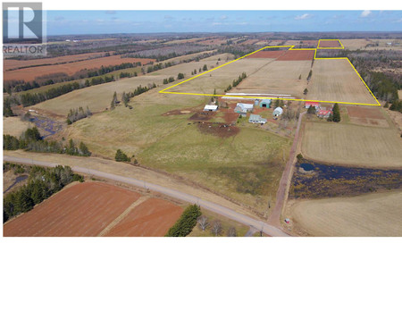
This Vacant Lot at 6722 Rte 19 Canoe Cove, PE with the MLS Number 202522955 listed by John Dicker - ROYAL LEPAGE PRINCE EDWARD REALTY on the Canoe Cove market 3 months ago at $1,400,000.
*LAND ONLY* Welcome to this beautifully maintained and worked acreage located in the desirable location of Canoe Cove. With stunning views of the Northumberland strait, you can not possibly get bored of working this land! There are approximately 150 acres in total, roughly 122 Arable and 28 treed acres across three separate PID's to add to your existing portfolio or enough to start your new farm operation. Access to land from New Argyle Rd. This land is sure to please! (id:1945)

This listing content provided by
REALTOR.ca
has been licensed by REALTOR®
members of The Canadian Real Estate Association
members of The Canadian Real Estate Association
Exterior & Lot Features
Learn about the exterior and lot specifics of 6722 Rte 19
Location & Community
Understand the neighborhood and community
Utilities & Systems
Review utilities and system installations
Tax & Legal Information
Get tax and legal details applicable to 6722 Rte 19
Additional Features
Explore extra features and benefits
Nearby Listings Stat Estimated price and comparable properties near 6722 Rte 19
Nearby Places Nearby schools and amenities around 6722 Rte 19
Price History
September 10, 2025
by ROYAL LEPAGE PRINCE EDWARD REALTY
$1,400,000