Lot Highway 224, Elmsvale

Lot Highway 224, Elmsvale, NS B0N1X0 Photo 1

12 Photos

Lot Highway 224, Elmsvale, NS B0N1X0 Photo 2
Lot Highway 224, Elmsvale, NS B0N1X0 Photo 3
Lot Highway 224, Elmsvale, NS B0N1X0 Photo 4
Lot Highway 224, Elmsvale, NS B0N1X0 Photo 5
Lot Highway 224, Elmsvale, NS B0N1X0 Photo 6
Lot Highway 224, Elmsvale, NS B0N1X0 Photo 7
  • MLS®: 202323941
  • Type: Lots and Land
  • Added: 173 days ago

Property Details

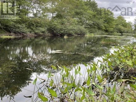
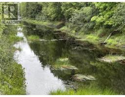
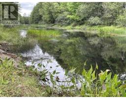
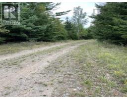
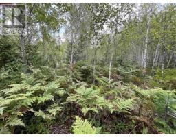
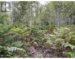
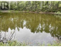
This stunning 114 acre property offers 2030 feet of waterfront along the beautiful Musquodoboit River. The road runs through the middle of the property, which offers the possibility to subdivide or develop. There is also a large pond on the property, perfect for swimming and fishing. Located just 10 minutes from the convenience of Middle Musqodoboit, 30 minutes from Elmsdale and 1 hour to Bayers Lake, with mixed use zoning which allows many different uses, the possibilities are truly endless This property has the potential you've been dreaming of. (id:1945)

Property Information

  • View: River view
  • Sewer: No sewage system
  • Lot Features: Level lot, Treed, Hardwood bush, Softwood bush
  • Photos Count: 12
  • Water Source: Lake/River Water Intake
  • Lot Size Units: acres
  • Parcel Number: 40860835
  • Common Interest: Freehold
  • Lot Size Dimensions: 114
  • Waterfront Features: Waterfront on river
This listing content provided by REALTOR.ca has been licensed by REALTOR®
members of The Canadian Real Estate Association

Nearby Places

Name Type Address Distance
Musquodoboit Valley Provincial Park Park Middle Musquodoboit 4.3 km
Musquodoboit Rural High School School 6.1 km
Musquodoboit Rural High School School 11980 Nova Scotia 224 6.1 km
RBC Royal Bank Atm 12332 Nova Scotia 224 7.5 km
Upper Musquodoboit Consolidated School School Halifax 11.2 km
Lanesville, Nova Scotia Lanesville is a community in the Canadian province... 14.5 km
Elderbank Provincial Park Park Middle Musquodoboit 16.3 km
Middle Stewiacke Airport Airport Lanesville 16.3 km
Bev's Country Diner Restaurant Upr Stewiacke 16.6 km
Stewiacke Valley Museum Museum 5445 289 Hwy 16.7 km
West St. Andrews Andrews is a community in the Canadian province of... 18.0 km
East Stewiacke East Stewiacke is mainly a farming and rural bedro... 18.8 km

Demographic Information

Neighbourhood Education

Bachelor's degree 30
University / Below bachelor level 10
Certificate of Qualification 10
College 95
University degree at bachelor level or above 30

Neighbourhood Marital Status Stat

Married 265
Widowed 50
Divorced 45
Separated 20
Never married 95
Living common law 70
Married or living common law 330
Not married and not living common law 210

Neighbourhood Construction Date

1961 to 1980 115
1981 to 1990 45
1991 to 2000 10
2001 to 2005 35
2006 to 2010 10
1960 or before 75
Nearby Cities Listings Avg. price
Dartmouth 52 $737.262
Halifax 175 $908.609
Brighton 102 $686.206
Stratford 76 $532.130
Charlottetown 178 $528.290
Dieppe 127 $686.535
Bouctouche 67 $193.307
Summerside 116 $395.578
Popular Cities Listings Avg. price
Moncton 320 $527.852
St John S 347 $572.765
Ottawa 2094 $875.761
Kawartha Lakes 496 $932.187
Oshawa 426 $1.022.363
Whitby 332 $1.201.268
Fort Erie 357 $916.138
Other 1394 $992.628
189 Highway 224, Sheet Harbour