470 11 Th Line South Sherbrooke Road, Maberly

470 11 Th Line South Sherbrooke Road, Maberly, ON K0H2B0 Photo 1

15 Photos

470 11 Th Line South Sherbrooke Road, Maberly, ON K0H2B0 Photo 2
470 11 Th Line South Sherbrooke Road, Maberly, ON K0H2B0 Photo 3
470 11 Th Line South Sherbrooke Road, Maberly, ON K0H2B0 Photo 4
470 11 Th Line South Sherbrooke Road, Maberly, ON K0H2B0 Photo 5
470 11 Th Line South Sherbrooke Road, Maberly, ON K0H2B0 Photo 6
470 11 Th Line South Sherbrooke Road, Maberly, ON K0H2B0 Photo 7
  • MLS®: 1335697
  • Type: Lots and Land
  • Added: 373 days ago

Property Details

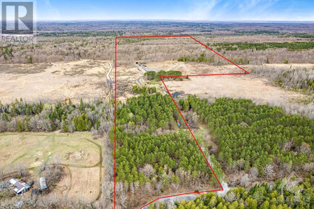
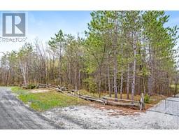
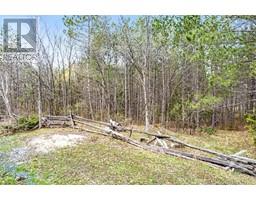
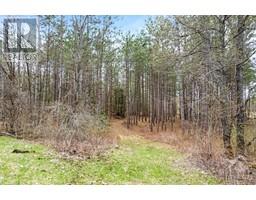
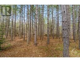
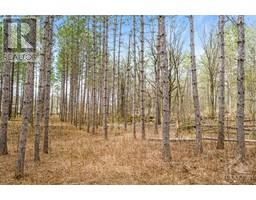
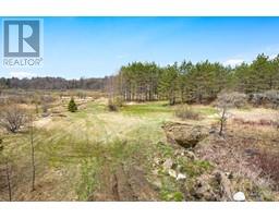
Great variety of natural features found throughout this 78 acres. Along with a drilled well on the property, you have high and dry land, bedrock outcropping, ponds, and approx 3 acre Jack Pine plantation at the road frontage. The varied landscape has an array of ecosystems, soil types, and microclimates and is as close to nature as you can get. Dramatic mix of land offers opportunities for activities such as hiking, camping, observing wildlife in the natural wetland areas on the land. The ponds provide habitat for water-loving plants and birds. While walking the numerous trails, you will find bedrock outcroppings, mixture of hardwoods and softwoods plus microhabitats for birds and animals. Wesley’s Creek runs through and around the property. Starlink is available in the area. Limited cell service. Nearest hydro approx 1745' west of the property. The Rural zoning permits many uses, including building your home. 25 mins Perth. 1 hr to Kanata or Kingston. (id:1945)

Property Information

  • List AOR: Ottawa
  • Tax Year: 2022
  • Basement: Not Applicable, Unknown
  • Lot Features: Acreage, Private setting, Treed, Wooded area
  • Photos Count: 15
  • Water Source: Drilled Well, Well
  • Lot Size Units: acres
  • Parcel Number: 052050033
  • Tax Annual Amount: 634
  • Lot Size Dimensions: 78.8
  • Zoning Description: Rural
This listing content provided by REALTOR.ca has been licensed by REALTOR®
members of The Canadian Real Estate Association

Nearby Places

Name Type Address Distance
Silver Lake Provincial Park Park Clarendon Station 2.2 km
Fall River Restaurant Bar 21980 Ontario 7 3.8 km
Wheelers Maple Products Restaurant 1001 Highland Line 9.3 km
Wheelers Pancake House and Sugar Camp Museum 1001 Highland Line 9.3 km
Camp Opemikon Campground 530 Hanna Rd 11.4 km
The Oaks Resort Real estate agency 1874-2044 Crow Lake Rd 13.9 km
Tay River Tent & Trailer Park Rv park 279 Christie Lake North Shore Rd 14.1 km
Sharbot Lake Provincial Park Park 25467 Trans-Canada Hwy 14.9 km
Wolfe Lake The nearest village is Westport... 20.5 km
Little Stream Bakery Bakery 667 Glen Tay Rd 21.3 km
Fall River (Ontario) It is part of the Saint Lawrence River drainage ba... 21.6 km
Clyde River (Ontario) It is in the Saint Lawrence River drainage basin, ... 22.2 km

Demographic Information

Neighbourhood Education

Bachelor's degree 15
University / Below bachelor level 10
Certificate of Qualification 15
College 85
University degree at bachelor level or above 20

Neighbourhood Marital Status Stat

Married 225
Widowed 15
Divorced 20
Separated 10
Never married 85
Living common law 40
Married or living common law 270
Not married and not living common law 130

Neighbourhood Construction Date

1961 to 1980 30
1981 to 1990 30
1991 to 2000 15
2001 to 2005 10
2006 to 2010 20
1960 or before 95
Nearby Cities Listings Avg. price
Carleton Place Homes for Sale 100 $880.379
Peterborough Homes for Sale 133 $833.362
Kingston Homes for Sale 206 $769.417
Napanee Homes for Sale 88 $782.787
Renfrew Homes for Sale 76 $478.984
Brockville Homes for Sale 80 $621.205
Kemptville Homes for Sale 125 $768.011
Greater Napanee Homes for Sale 84 $1.700.649
Popular Cities Listings Avg. price
Ottawa Homes for Sale 2127 $872.169
Kawartha Lakes Homes for Sale 501 $932.514
Oshawa Homes for Sale 428 $1.019.747
Whitby Homes for Sale 335 $1.199.776
Other Homes for Sale 1395 $992.297
Markham Homes for Sale 526 $1.387.911
Innisfil Homes for Sale 333 $1.439.200
Richmond Hill Homes for Sale 488 $1.651.854