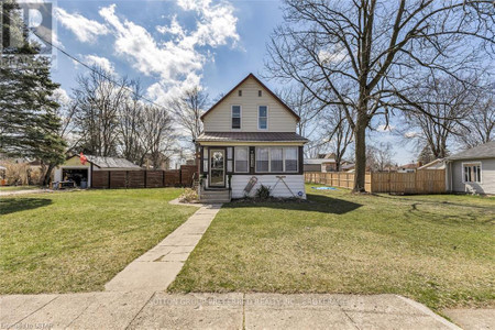
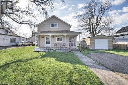
9590 Currie Road, Wallacetown
- Bedrooms: 3
- Bathrooms: 2
- Living area: 1440 sqft
- Type: Residential
Source: Public Records
Property Details
Note: This property is not currently for sale or for rent on Ovlix.
We have found 6 Houses that closely match the specifications of the property located at 9590 Currie Road with distances ranging from 2 to 5 kilometers away. The prices for these similar properties vary between 305,000 and 449,900, providing a good range for comparison. Moreover, we have also discovered that there are a few open Houses in the N0L2M0 postal code area of Wallacetown Ontario Canada.
Property Location
- City: Wallacetown
- Country: Canada
- Latitude: 42.63624019
- Province: Ontario
- Longitude: -81.46682036
- Postal Code: N0L2M0
- Street Name: CURRIE
- Subdivision: Wallacetown
- Street Number: 9590
- Street Suffix: Road
- Street Address: 9590 CURRIE Road
Nearby Places
| Name | Type | Address | Distance |
| Southwold Earthworks | Establishment | Part Of | 9.8 km |
| West Elgin Secondary School | WESS is part of the Thames Valley District School ... | 11.6 km | |
| West Elgin Secondary School | School | 139 Graham Rd | 11.6 km |
| West Lorne Baptist Church | West Lorne Baptist Church, is an Evangelical Chris... | 11.9 km | |
| Rodney (New Glasgow) Airport | Rodney (New Glasgow) Airport, (TC LID: CPU3), is l... | 16.4 km | |
| West Elgin, Ontario | The township was created on January 1, 1998, throu... | 17.4 km | |
| Sixteenmile Creek (Ontario) | It is part of the Great Lakes Basin, and flows fro... | 18.8 km | |
| Oneida Nation of the Thames | Health | 2212 Elm Ave | 20.7 km |
| Port Stanley Terminal Rail | Establishment | 309 Bridge St | 20.9 km |
| Kettle Creek (Ontario) | Kettle Creek flows through parts of London, Ontari... | 21.7 km | |
| Melbourne Airport | Airport | Melbourne | 22.0 km |
| Parkside Collegiate Institute | School | 241 Sunset Dr | 26.1 km |
Demographic Information
Neighbourhood Education
| Bachelor's degree | 25 |
| Certificate of Qualification | 25 |
| College | 105 |
| University degree at bachelor level or above | 30 |
Neighbourhood Marital Status Stat
| Married | 285 |
| Widowed | 30 |
| Divorced | 25 |
| Separated | 5 |
| Never married | 100 |
| Living common law | 65 |
| Married or living common law | 345 |
| Not married and not living common law | 160 |
Neighbourhood Construction Date
| 1961 to 1980 | 30 |
| 1981 to 1990 | 20 |
| 1991 to 2000 | 30 |
| 2001 to 2005 | 20 |
| 2006 to 2010 | 10 |
| 1960 or before | 105 |