74 Industrial Drive, Hartland

74 Industrial Drive, Hartland, NB E7P2G8 Photo 1

36 Photos

74 Industrial Drive, Hartland, NB E7P2G8 Photo 2
74 Industrial Drive, Hartland, NB E7P2G8 Photo 3
74 Industrial Drive, Hartland, NB E7P2G8 Photo 4
74 Industrial Drive, Hartland, NB E7P2G8 Photo 5
74 Industrial Drive, Hartland, NB E7P2G8 Photo 6
74 Industrial Drive, Hartland, NB E7P2G8 Photo 7
  • MLS®: nb095547
  • Type: Commercial
  • Added: 85 days ago

Property Details

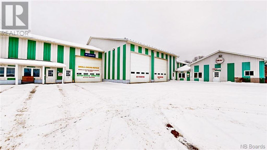
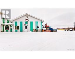
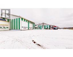
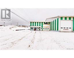
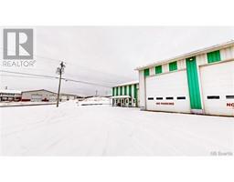
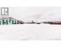
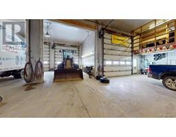
Sitting on 1.46 acre lot, this approx. 29,000 sqft Industrial building also has mezzanines adding another 4,000 sqft. Building has 400 amp/3 phase electrical service. Heat is a combination of electric baseboard, suspended fan and waste oil furnace unit. Exterior siding is pre-painted steel. Ceiling heights vary from 8 ft. in the office areas and 18 ft. in the shop areas. Roof was replaced in 2004. There are three 15ft. overhead doors. The town of Harland is situated in the central western portion of the province approx. 20 kms north of the town of Woodstock and 20 kms south of the town of Florenceville/Bristol. Hartland, famous for the World's Longest Covered Bridge, is also HO to Day and Ross, the transportation arm of the McCain Group of Companies. (id:1945)

Property Information

  • Roof: Metal, Unknown
  • Heating: Baseboard heaters, Oil, Electric
  • Lot Features: Level lot, Industrial mall/subdivision
  • Photos Count: 36
  • Business Type: Industrial
  • Lot Size Units: square meters
  • Parcel Number: 10107217
  • Tax Annual Amount: 17751.55
  • Exterior Features: Metal
  • Security Features: Monitored Alarm
  • Lot Size Dimensions: 5925
  • Zoning Description: L1
  • Above Grade Finished Area: 29000
  • Above Grade Finished Area Units: square feet
This listing content provided by REALTOR.ca has been licensed by REALTOR®
members of The Canadian Real Estate Association

Nearby Places

Name Type Address Distance
Hartland, New Brunswick Hartland (2011 population: 947) is a town in Carle... 0.4 km
Hartland Bridge It crosses the Saint John River from Hartland to S... 0.9 km
Hartland Bridge Establishment Hartland Covered Bridge 0.9 km
Becaguimec Stream It rises in the hilly,woods along the county line ... 1.0 km
Hugh John Flemming Bridge The Hugh John Flemming Bridge is part of Route 130... 1.7 km
Somerville, New Brunswick Somerville is located on Route 103 between Wakefie... 2.1 km
New Brunswick Bible Institute New Brunswick Bible Institute, commonly called NBB... 2.7 km
Victoria Corner, New Brunswick Victoria Corner, New Brunswick is a community in C... 3.4 km
Simonds Parish, Carleton County, New Brunswick Its population in the 2006 Census was 489... 4.3 km
Upper River Valley Hospital Operated by Horizon Health Network, the Upper Rive... 4.3 km
Upper River Valley Hospital Hospital 11300 Rte 130 4.3 km
Northampton, New Brunswick Northampton is a Canadian community in Carleton Co... 4.5 km

Demographic Information

Neighbourhood Education

Bachelor's degree 25
Certificate of Qualification 15
College 70
University degree at bachelor level or above 30

Neighbourhood Marital Status Stat

Married 230
Widowed 70
Divorced 35
Separated 15
Never married 105
Living common law 35
Married or living common law 265
Not married and not living common law 220

Neighbourhood Construction Date

1961 to 1980 70
1981 to 1990 45
1991 to 2000 15
2001 to 2005 10
2006 to 2010 15
1960 or before 35
Nearby Cities Listings Avg. price
Fredericton 108 $460.060
Riverview 69 $592.282
Edmundston 101 $312.467
Quispamsis 74 $358.297
Saint John 167 $445.557
Miramichi 86 $261.424
Shediac 88 $634.727
Bathurst 75 $411.193
Popular Cities Listings Avg. price
Ottawa 2102 $895.339
Kawartha Lakes 479 $950.950
Oshawa 417 $1.040.512
Whitby 314 $1.210.911
Other 1402 $999.279
Fort Erie 373 $895.966
Markham 522 $1.397.791
Innisfil 323 $1.427.821
149 High Street, Hartland 14 Crescent Gardens, Hartland 148 High Street, Hartland 18 Craig Court, Hartland 1 Cresent Garden, Hartland 160 Rockland Road, Hartland 18 Hawthorne Street, Hartland 52 Orser Street, Hartland