00 St Philippe Street, Alfred

00 St Philippe Street, Alfred, ON K0B1A0 Photo 1

11 Photos

00 St Philippe Street, Alfred, ON K0B1A0 Photo 2
00 St Philippe Street, Alfred, ON K0B1A0 Photo 3
00 St Philippe Street, Alfred, ON K0B1A0 Photo 4
00 St Philippe Street, Alfred, ON K0B1A0 Photo 5
00 St Philippe Street, Alfred, ON K0B1A0 Photo 6
00 St Philippe Street, Alfred, ON K0B1A0 Photo 7
  • MLS®: 1383175
  • Type: Lots and Land
  • Added: 33 days ago

Property Details

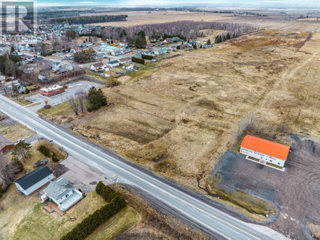
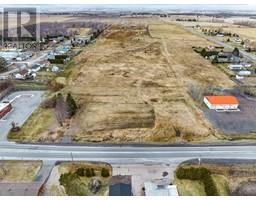
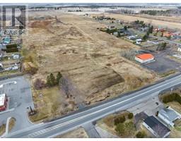
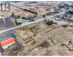
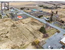
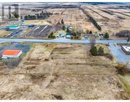
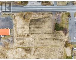
LOCATION LOCATION LOCATION!!! 1.49 Acre Commercial Lot zoned C3 (Hwy Commercial) on St-Philippe street in Alfred next to Tim Horton's. Ideal location to establish your business on this piece of land with high visibility and traffic. Endless possibilities of construction from Auto Service Station, Warehouse, Welding Shop and Hotel to restaurant. Water and natural gas available but will have to be connected at the Buyer's expense. Don't wait! (id:1945)

Property Information

  • List AOR: Cornwall
  • Tax Year: 2023
  • Photos Count: 11
  • Water Source: None
  • Lot Size Units: acres
  • Parcel Number: 541320412
  • Common Interest: Freehold
  • Tax Annual Amount: 985
  • Lot Size Dimensions: 1.49
  • Zoning Description: C3 Hwy Commercial
This listing content provided by REALTOR.ca has been licensed by REALTOR®
members of The Canadian Real Estate Association

Nearby Places

Name Type Address Distance
Restaurant Le Chardo Restaurant 374 Hwy 17 & Regional Road 15 0.9 km
Cedar Shade Campground Campground 530 Peladeau 3.4 km
Alfred and Plantagenet The township was formed on January 1, 1997, throug... 3.5 km
Evergreen Camping & Resort Campground 5279 Chemin de Comté 17 4.5 km
Hawkesbury (Windover Field) Airport Hawkesbury (Windover Field) Airport, (TC LID: CPD8... 4.9 km
Caledonia Springs, Ontario It is part of the National Capital Region and is i... 5.9 km
Alfred Bog The bog is considered the largest high-quality bog... 8.1 km
L'Orignal Packing Ltd Food 2567 Route 17 8.7 km
Champlain Motel & Restaurant Restaurant 269 Old Highway 17 9.5 km
Plantagenet Public School School 635 Water St 10.0 km
Domaine Chartrand Camping Campground 2775 Chartrand Rd 10.5 km
Manoir Papineau National Historic Site Establishment 500 Notre-Dame 11.0 km

Demographic Information

Neighbourhood Education

Bachelor's degree 15
Certificate of Qualification 10
College 70
University degree at bachelor level or above 20

Neighbourhood Marital Status Stat

Married 185
Widowed 55
Divorced 30
Separated 15
Never married 115
Living common law 110
Married or living common law 300
Not married and not living common law 220

Neighbourhood Construction Date

1961 to 1980 50
1981 to 1990 50
1991 to 2000 65
2001 to 2005 10
2006 to 2010 15
1960 or before 30
Nearby Cities Listings Avg. price
Orleans 100 $724.531
Gatineau Gatineau 114 $602.717
Ottawa 2149 $893.622
Gatineau Hull 66 $647.424
Rockland 96 $632.356
Gatineau Aylmer 67 $637.577
Embrun 74 $629.793
Val Des Monts 63 $417.535
Popular Cities Listings Avg. price
Kawartha Lakes 481 $948.239
Oshawa 427 $1.035.120
Whitby 326 $1.212.777
Other 1402 $999.279
Innisfil 321 $1.424.386
Markham 524 $1.384.619
Barrie 931 $1.018.616
Richmond Hill 466 $1.622.036
421 St Philippe Street, Alfred 561 Bolt Road, Alfred 385 St Philippe Street, Alfred 376 St Mary Street, Alfred 367 St Joseph Street, Alfred 364 St Mary Street, Alfred 159 161 St Philippe Street, Alfred 344 St Philippe Street, Alfred