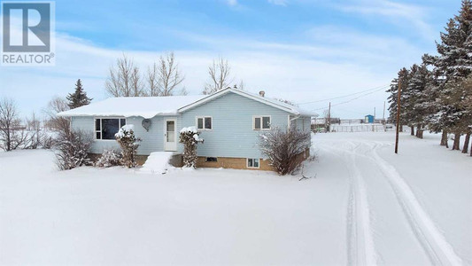
12414 602 Highway, Alliance
- Bedrooms: 4
- Bathrooms: 2
- Living area: 1730 sqft
- Type: Residential
Source: Public Records
Property Details
Note: This property is not currently for sale or for rent on Ovlix.
We have found 1 Houses that closely match the specifications of the property located at 12414 602 Highway with distances ranging from 2 to 0 kilometers away. The prices for these similar properties vary between 425,000 and 425,000, providing a good range for comparison. Moreover, we have also discovered that there are a few open Houses in the T0B0A0 postal code area of Alliance Alberta Canada.
Property Location
- City: Alliance
- Country: Canada
- Latitude: 52.434536
- Province: Alberta
- Longitude: -111.688186
- Postal Code: T0B0A0
- Street Name: 602
- Street Number: 12414
- Street Suffix: Highway
- Street Address: 12414 602 Highway
Nearby Places
| Name | Type | Address | Distance |
| Brownfield Community School | School | Box 54 | 21.8 km |
| Theresetta Roman Catholic Separate School | School | 5409 47th St | 27.8 km |
| Clearview School Division | School | 5402 47 St | 27.8 km |
| Gus Wetter School | School | 5018 50 Ave | 28.1 km |
| Theresetta School Early Childhood Society | School | 5018 50 Ave | 28.1 km |
| Town Of Castor | Campground | 4905 50 Ave | 28.2 km |
Demographic Information
Neighbourhood Education
| Master's degree | 10 |
| Bachelor's degree | 20 |
| Certificate of Qualification | 25 |
| College | 40 |
| University degree at bachelor level or above | 30 |
Neighbourhood Marital Status Stat
| Married | 225 |
| Widowed | 10 |
| Divorced | 15 |
| Separated | 5 |
| Never married | 85 |
| Living common law | 35 |
| Married or living common law | 260 |
| Not married and not living common law | 115 |
Neighbourhood Construction Date
| 1961 to 1980 | 35 |
| 1981 to 1990 | 35 |
| 1991 to 2000 | 10 |
| 2001 to 2005 | 20 |
| 2006 to 2010 | 10 |
| 1960 or before | 40 |