1830 Durham Regional 12 Rd, Brock

1830 Durham Regional 12 Rd, Brock, ON L0E1E0 Photo 1

27 Photos

1830 Durham Regional 12 Rd, Brock, ON L0E1E0 Photo 2
1830 Durham Regional 12 Rd, Brock, ON L0E1E0 Photo 3
1830 Durham Regional 12 Rd, Brock, ON L0E1E0 Photo 4
1830 Durham Regional 12 Rd, Brock, ON L0E1E0 Photo 5
1830 Durham Regional 12 Rd, Brock, ON L0E1E0 Photo 6
1830 Durham Regional 12 Rd, Brock, ON L0E1E0 Photo 7
  • MLS®: n8103216
  • Type: Lots and Land
  • Added: 65 days ago

Property Details

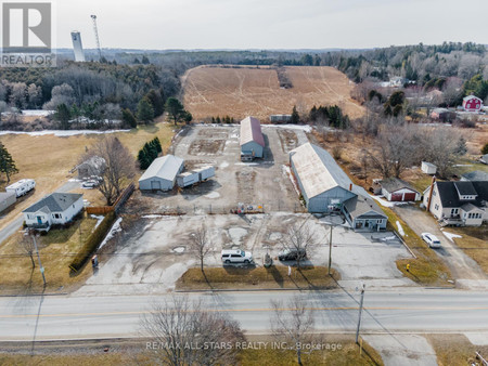
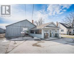
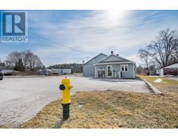
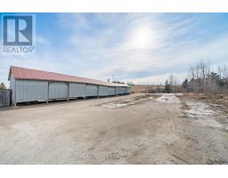
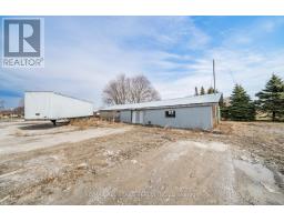
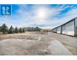
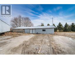
An excellent opportunity in growing community of North Durham-Cannington! 20-40 minutes to urban centres of Newmarket/Stouffville/Lindsay/Port Perry; former building supply location of Arksey Lumber-owners have retired; future redevelopment opportunity of 1.93 acres; municipal water at lot line; level,graveled site located within urban boundary of Cannington; adjacent uses are single family residential with future residential development adjacent to south and across Regional Road 12 to the north; good 40'8"" x 132' pole constructed building with electrical (uninsulated) with attached 26'8"" x 22'5"" retail/office area; lumber shed and drive shed; fenced site; adjacent house to the west is also available. (id:1945)

Property Information

  • Heating: Baseboard heaters
  • Photos Count: 27
  • Business Type: Residential
  • Tax Annual Amount: 13808.78
  • Lot Size Dimensions: 202 x 417 FT ; Depth Irreg-Measurements From Geoware.
This listing content provided by REALTOR.ca has been licensed by REALTOR®
members of The Canadian Real Estate Association

Nearby Places

Name Type Address Distance
Cannington, Ontario The town is on the Beaver River.... 2.0 km
Brock High School School 1590 Regional Rd 12 4.1 km
Brock High School (Ontario) It is the north most high school in the Durham Dis... 4.1 km
Brock, Ontario Brock Township is also a former municipality and g... 6.7 km
Sunderland, Ontario This is currently one of the very few populated ar... 10.8 km
Vroomanton, Ontario The farming town was founded by Colonel James Vroo... 11.8 km
Beaverton Aerodrome Airport Canada 12.3 km
Sonya, Ontario It is located 3 km north of Seagrave on Simcoe Str... 14.3 km
Beaverton North Aerodrome Airport Canada 14.5 km
Pefferlaw, Ontario A river, known officially as the Pefferlaw River, ... 15.3 km
Anglican Diocese of Toronto It has the most members of any Anglican diocese in... 15.8 km
Talbot River (Ontario) The lower section of the river is now part of the ... 17.4 km

Demographic Information

Neighbourhood Education

Bachelor's degree 50
Certificate of Qualification 40
College 40
University degree at bachelor level or above 55

Neighbourhood Marital Status Stat

Married 220
Widowed 20
Divorced 25
Separated 15
Never married 105
Living common law 45
Married or living common law 265
Not married and not living common law 170

Neighbourhood Construction Date

1961 to 1980 55
1981 to 1990 35
1960 or before 80
Nearby Cities Listings Avg. price
Port Colborne Real Estate 150 $878.597
Brantford Real Estate 513 $946.983
Wainfleet Real Estate 69 $1.228.933
Welland Real Estate 298 $1.020.478
Crystal Beach Real Estate 67 $636.826
Fonthill Real Estate 54 $1.239.248
Ridgeway Real Estate 63 $904.531
Essex Real Estate 52 $1.023.970
Popular Cities Listings Avg. price
Niagara Falls Real Estate 669 $1.097.674
Hamilton Real Estate 2213 $1.126.256
St Catharines Real Estate 564 $871.519
Fort Erie Real Estate 364 $902.604
Burlington Real Estate 778 $1.559.635
Oakville Real Estate 858 $1.953.446
Cambridge Real Estate 419 $1.041.867
Milton Real Estate 394 $1.771.023
1769 C Cameron St, Brock 276 Cameron St, Brock 276 Carmeron St, Brock 425 Cameron St E, Brock 2300 Cameron St E, Brock 3557 Regional Road 12 Road, Grassie 3557 Regional Road 12 Rd, Grimsby C 520 Regional Rd 12, Brock