00 Mccarthys Point Road, Pocologan

00 Mccarthys Point Road, Pocologan, NB E5H0B4 Photo 1

22 Photos

00 Mccarthys Point Road, Pocologan, NB E5H0B4 Photo 2
00 Mccarthys Point Road, Pocologan, NB E5H0B4 Photo 3
00 Mccarthys Point Road, Pocologan, NB E5H0B4 Photo 4
00 Mccarthys Point Road, Pocologan, NB E5H0B4 Photo 5
00 Mccarthys Point Road, Pocologan, NB E5H0B4 Photo 6
00 Mccarthys Point Road, Pocologan, NB E5H0B4 Photo 7
  • MLS®: nb088909
  • Type: Lots and Land
  • Added: 303 days ago

Property Details

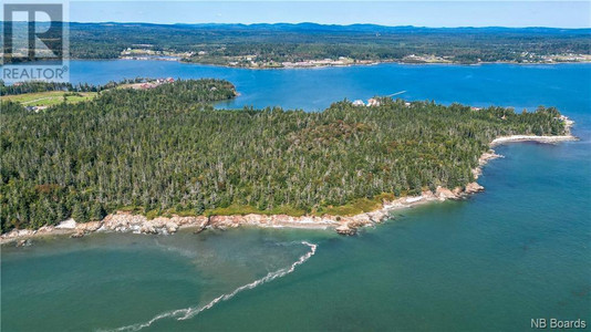
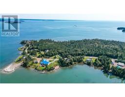
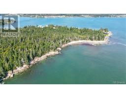
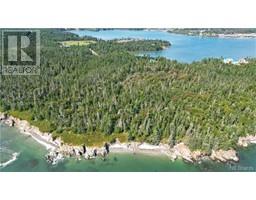
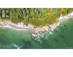
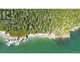
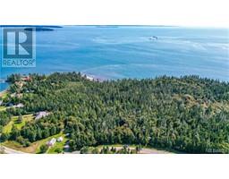
This is two lots with 2400 ft. of water frontage on the ocean, beach and rocky nb coastline with a view unsurpassed of the open ocean and Pocologan Island. It has 1000 ft. on McCarthy's Point Road. The lots are wooded. Which would lend itself to several private ocean-view home sites with plenty of privacy. Or investment for the future as oceanfront is getting scarce. (id:1945)

Property Information

  • Sewer: No sewage system
  • Directions: From Route # 1 turn onto Route #175(old #1) and trevel to Pocologan turn south onto McCarthy's Point Road . The property is on the right see signs. Aproximately 1000 ft. frontage on the McCarthys Point Road
  • Lot Features: Treed
  • Photos Count: 22
  • Possible Use: Development residential, Recreational
  • Water Source: None
  • Lot Size Units: acres
  • Parcel Number: 01344266
  • Water Body Name: Bay of Fundy
  • Tax Annual Amount: 2466
  • Lot Size Dimensions: 35
  • Zoning Description: Res
  • Waterfront Features: Waterfront on ocean
This listing content provided by REALTOR.ca has been licensed by REALTOR®
members of The Canadian Real Estate Association

Nearby Places

Name Type Address Distance
Crow Harbour, New Brunswick Crow Harbour is a Canadian unincorporated communit... 2.9 km
Seeleys Cove, New Brunswick Seeleys Cove is a Canadian unincorporated communit... 5.8 km
New Brunswick Route 780 Route 780 is a 29-kilometre (18 mi) long mostly we... 6.8 km
Pennfield Ridge, New Brunswick Pennfield Ridge is a Canadian unincorporated commu... 7.5 km
RCAF Station Pennfield Ridge RCAF Station Pennfield Ridge was a Royal Canadian ... 7.8 km
Pennfield Elementary School School 18 School 11.3 km
Pennfield, New Brunswick Pennfield is also referred to sometimes as Pennfie... 11.4 km
Lepreau Falls Park Lepreau 12.1 km
Beaver Harbour, New Brunswick It is located east of Blacks Harbour and south of ... 12.6 km
New Brunswick Route 778 Route 778 is a 10.8-kilometre (6.7 mi) long north ... 12.9 km
Justasons Corner, New Brunswick Justasons Corner is a Canadian unincorporated comm... 13.2 km
Utopia, New Brunswick Utopia is a Canadian unincorporated community in C... 14.2 km

Demographic Information

Neighbourhood Education

Bachelor's degree 25
University / Below bachelor level 15
College 90
University degree at bachelor level or above 25

Neighbourhood Marital Status Stat

Married 200
Widowed 20
Divorced 25
Separated 15
Never married 80
Living common law 35
Married or living common law 235
Not married and not living common law 140

Neighbourhood Construction Date

1961 to 1980 55
1981 to 1990 45
1991 to 2000 35
2001 to 2005 15
2006 to 2010 10
1960 or before 35
Nearby Cities Listings Avg. price
Riverview Homes for Sale 71 $539.526
Saint John Homes for Sale 165 $489.256
Quispamsis Homes for Sale 76 $360.105
Fredericton Homes for Sale 105 $464.289
Yarmouth Homes for Sale 58 $335.457
Shediac Homes for Sale 86 $568.792
Moncton Homes for Sale 312 $511.860
Dieppe Homes for Sale 119 $710.143
Popular Cities Listings Avg. price
Ottawa Homes for Sale 2033 $894.194
Kawartha Lakes Homes for Sale 489 $938.734
Oshawa Homes for Sale 417 $1.041.757
Whitby Homes for Sale 325 $1.211.135
Fort Erie Homes for Sale 367 $901.371
Other Homes for Sale 1397 $992.161
Markham Homes for Sale 521 $1.383.139
Niagara Falls Homes for Sale 665 $1.101.689
63 Pocologan Causeway Road, Pocologan 43 Mccarthys Point Road, Pocologan