378 Apache Trail, St Andrews

378 Apache Trail, St Andrews, MB R1A3M5 Photo 1

2 Photos

378 Apache Trail, St Andrews, MB R1A3M5 Photo 2
  • MLS®: 202401649
  • Type: Lots and Land
  • Added: 94 days ago

Property Details

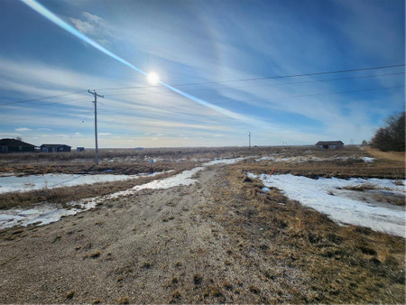
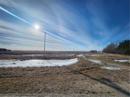
R13//St Andrews/BUILD YOUR OWN CUSTOM COUNTRYSIDE DREAM HOME IN ST. ANDREWS! Property is 4.36 acres and includes a driveway, approach, well, holding tank, and hydro pole. Property is approximately 10 minutes from the North Perimeter Highway. Still some older structures on property. Former residence has been removed. Property is located near the St. Andrews Airport. (id:1945)

Property Information

  • Sewer: Holding Tank
  • Tax Year: 2021
  • Photos Count: 2
  • Water Source: Well
  • Lot Size Units: acres
  • Structure Type: No Building
  • Common Interest: Freehold
  • Tax Annual Amount: 1893.65
  • Lot Size Dimensions: 4.360
This listing content provided by REALTOR.ca has been licensed by REALTOR®
members of The Canadian Real Estate Association

Nearby Places

Name Type Address Distance
St. Andrews Airport Andrews Airport or Winnipeg/St... 1.5 km
St. Andrews Airport Airport St Andrews 1.6 km
Saint Andrews School School 8 St Andrews Rd 5.0 km
St. Paul (Manitoba electoral district) Paul is a provincial electoral division in the Can... 7.5 km
Rural Municipality of West St. Paul Paul is a rural municipality in Manitoba, Canada... 7.6 km
Lockport, Manitoba The community is a part of both the Rural Municipa... 7.7 km
Oak Hammock Air Park Airport Oak Hammock Air Park Airport, (TC LID: CAV9), is l... 8.1 km
Oak Hammock Air Park Airport Airport Canada 8.1 km
Half Moon Drive In Restaurant 6860 Henderson Hwy 8.4 km
Red River Floodway It is a 47 km (29 mi) long channel which, during f... 8.6 km
Lower Fort Garry National Historic Site Cafe 5925 Highway 9 9.5 km
Lower Fort Garry Treaty 1 was signed there... 9.8 km
Similar Vacant Lots Stat in St Andrews
We have found 6 Land that closely match the specifications of the property located at 378 Apache Trail with distances ranging from 2 to 10 kilometers away. The prices for these similar properties vary between 297,900 and 319,900, providing a good range for comparison. Moreover, we have also discovered that there are a few open Land in the R1A3M5 postal code area of St Andrews Manitoba Canada.

Demographic Information

Neighbourhood Education

Bachelor's degree 50
University / Below bachelor level 10
Certificate of Qualification 40
College 95
Degree in medicine 10
University degree at bachelor level or above 70

Neighbourhood Marital Status Stat

Married 365
Widowed 15
Divorced 15
Separated 5
Never married 155
Living common law 50
Married or living common law 410
Not married and not living common law 190

Neighbourhood Construction Date

1961 to 1980 100
1981 to 1990 45
1991 to 2000 35
2001 to 2005 25
2006 to 2010 25
1960 or before 30
Comparison of 378 Apache Trail, St Andrews, MB with Nearby Vacant Lots
Nearby Cities Listings Avg. price
West St Paul 99 $590.852
Winnipeg 1404 $544.074
Steinbach 122 $532.420
Niverville 64 $467.114
Brandon 73 $353.087
La Broquerie 57 $224.090
Melville 75 $166.235
Yorkton 116 $541.655
Popular Cities Listings Avg. price
Regina 857 $406.834
Saskatoon 935 $507.391
Other 691 $785.683
Lethbridge 332 $478.722
Edmonton 3855 $636.663
Calgary 2607 $817.116
Windsor 656 $816.778
Wasaga Beach 328 $866.186
1051 Porcher Road, St Andrews