1218 Garrison Road, Fort Erie

1218 Garrison Road, Fort Erie, ON L2A1P1 Photo 1

20 Photos

1218 Garrison Road, Fort Erie, ON L2A1P1 Photo 2
1218 Garrison Road, Fort Erie, ON L2A1P1 Photo 3
1218 Garrison Road, Fort Erie, ON L2A1P1 Photo 4
1218 Garrison Road, Fort Erie, ON L2A1P1 Photo 5
1218 Garrison Road, Fort Erie, ON L2A1P1 Photo 6
1218 Garrison Road, Fort Erie, ON L2A1P1 Photo 7
  • Living area: 6985 sqft
  • MLS®: 40574812
  • Type: Commercial
  • Added: 13 days ago

Property Details

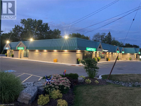
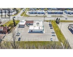
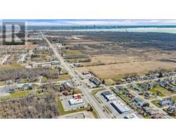
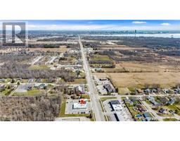
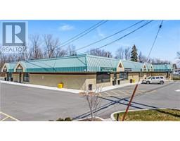
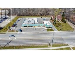
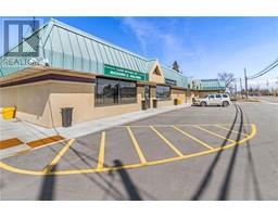
Fantastic Highway exposure near all amenities on the busiest street in Town sits this 7000 sq ft plaza fully occupied with commercial tenants over four separate units plus two storage units. The plaza has had extensive upgrades to the building/property ( see supplements). A phase 1 environmental study has been completed and the Town would likely approve an additional 3 stories for residential occupancy. Buyer to do own due diligence with the Town of Fort Erie. Plenty of on-site parking. Moments from the QEW and the Peace Bridge to USA. (id:1945)

Property Information

  • Sewer: Municipal sewage system
  • Stories: 1
  • Basement: Crawl space
  • Directions: ON GARRISON RD (HWY 3) BETWEEN CRESCENT RD AND PETTIT RD.
  • Living Area: 6985
  • Lot Features: Southern exposure
  • Photos Count: 20
  • Water Source: Municipal water
  • Parking Total: 40
  • Common Interest: Freehold
  • Subdivision Name: 334 - Crescent Park
  • Tax Annual Amount: 27900
  • Exterior Features: Brick, Stucco
  • Building Area Total: 6985
  • Community Features: High Traffic Area, School Bus
  • Zoning Description: C3
This listing content provided by REALTOR.ca has been licensed by REALTOR®
members of The Canadian Real Estate Association

Nearby Places

Name Type Address Distance
CFLZ-FM CFLZ's studios are located on Ontario Avenue in Ni... 0.9 km
Fort Erie Airport Fort Erie Airport, (TC LID: CNJ3), is a former air... 1.4 km
Anchor Bar The restaurant was initially established in 1935... 2.1 km
Fort Erie Race Track Fort Erie Race Track was at one time owned by the ... 2.6 km
Battle of Fort Erie (1866) The Fenian force, withdrawing from Ridgeway toward... 3.1 km
Capture of Fort Erie The British garrison was outnumbered but surrender... 3.3 km
Siege of Fort Erie From 4 August to 21 September 1814, the Americans ... 3.3 km
Canadian Motor Speedway The development is located on an 821 acres (332 he... 3.3 km
Old Fort Erie It is located on the southern edge of the Town of ... 3.3 km
Peace Bridge Arena Built in 1928, it held 5,000 people... 3.4 km
Peace Bridge For other Peace Bridges, see Peace Bridge (disambi... 4.5 km
Fort Erie, Ontario It is located directly across the river from Buffa... 4.7 km

Demographic Information

Neighbourhood Education

Bachelor's degree 35
Certificate of Qualification 10
College 65
University degree at bachelor level or above 35

Neighbourhood Marital Status Stat

Married 160
Widowed 15
Divorced 15
Separated 5
Never married 55
Living common law 20
Married or living common law 185
Not married and not living common law 90

Neighbourhood Construction Date

1961 to 1980 75
1981 to 1990 10
1991 to 2000 10
1960 or before 50
Nearby Cities Listings Avg. price
Ridgeway 63 $904.531
Crystal Beach 67 $636.826
Port Colborne 149 $882.145
Essex 52 $1.023.970
Brantford 511 $948.733
Welland 297 $1.021.964
Niagara Falls 665 $1.099.710
Fonthill 54 $1.240.266
Popular Cities Listings Avg. price
Hamilton 2175 $1.259.777
St Catharines 560 $872.655
Burlington 770 $1.567.466
Oakville 846 $1.965.630
Milton 389 $1.780.540
Toronto 7420 $1.171.951
Cambridge 412 $1.018.897
Mississauga 1373 $1.340.712
1670 Marina Dr, Fort Erie 229 Cherry Hill Lot A Boulevard S, Fort Erie 861 Burwell Street, Fort Erie 1472 Marina Dr, Fort Erie 229 Cherry Hill Lot D Boulevard S, Fort Erie 1069 Meadowood Street, Fort Erie 229 Cherry Hill Lot B Boulevard, Fort Erie 1073 Meadowood Street, Fort Erie