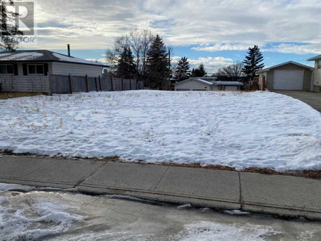
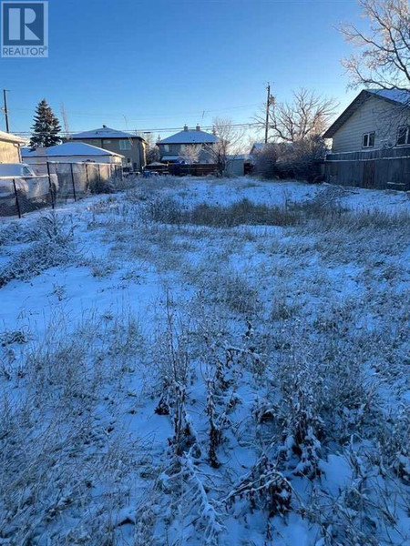
Name |
Type |
Address |
Distance |
Ogden, Calgary |
It includes the districts of Lynnwood and Millican... |
|
1.0 km |
Shepard Industrial, Calgary |
Although predominantly industrial, it contains a p... |
|
1.5 km |
Calgary Region |
It consists of the City of Calgary, Rocky View Cou... |
|
1.5 km |
Riverbend, Calgary |
It is bounded to the north by Glenmore Trail, to t... |
|
1.9 km |
Calgary-Fort |
The Electoral District is named after historical F... |
|
2.7 km |
Calgary Soccer Centre |
The soccer centre is owned and operated by the Cit... |
|
2.7 km |
Big Rock Brewery |
Food |
5555 76 Ave SE |
3.1 km |
Big Rock Brewery |
Big Rock Brewery is a brewery founded in 1985 in C... |
|
3.1 km |
Calgary Farmers' Market |
Grocery or supermarket |
510 77 Ave SE |
3.7 km |
Dover, Calgary |
It is bounded by 26 Avenue S to the north, Peigan ... |
|
3.7 km |
Erin Woods, Calgary |
It is located at the eastern edge of the city and ... |
|
4.2 km |
Alyth/Bonnybrook/Manchester, Calgary |
Alyth is located south of Inglewood, while Manches... |
|
4.2 km |
Fairview, Calgary |
It is bounded to the north by Glenmore Trail and 6... |
|
4.4 km |
Maple Ridge, Calgary |
The community is bounded to the east by Deerfoot T... |
|
4.4 km |
CPR Alyth Yard |
One of Canadian Pacific Railway's main marshalling... |
|
4.4 km |
Lord Beaverbrook High School |
It was founded in 1967 and the first year of atten... |
|
4.6 km |
Acadia, Calgary |
The area is bounded on the west by Macleod Trail, ... |
|
4.8 km |
Chinook (CTrain) |
The station opened on May 25, 1981 as part of the ... |
|
4.9 km |
Lester B. Pearson High School (Calgary) |
Pearson High School is a public senior high school... |
|
5.0 km |
Bolero |
Restaurant |
6920 Macleod Trail S |
5.1 km |
Cactus Club Cafe |
Restaurant |
7010 Macleod Trail South |
5.2 km |
Willow Park, Calgary |
It is bounded to the west by Macleod Trail, to the... |
|
5.3 km |
Southview, Calgary |
It is bounded by International Avenue to the north... |
|
5.3 km |
Heritage (CTrain) |
The station opened on May 25, 1981 as part of the ... |
|
5.4 km |
Chinook Centre |
Shopping mall |
6455 Macleod Trail Southwest |
5.4 km |
Chinook Centre |
Located near the geographic centre of the city on ... |
|
5.5 km |
Delta Calgary South |
Lodging |
135 Southland Dr SE |
5.5 km |
Kingsland, Calgary |
It is bounded to the north by Glenmore Trail, to t... |
|
5.6 km |
Meadowlark Park, Calgary |
It is located immediately west from the Chinook Ce... |
|
5.7 km |
Bishop Grandin High School |
School |
111 Haddon Rd SW |
5.7 km |
Canadian Tire |
Car repair |
9940 Macleod Trail SE |
5.7 km |
Southland Park |
The complex is Calgary's largest suburban office p... |
|
5.8 km |
Windsor Park, Calgary |
It is bounded by 50 Avenue S to the north, Macleod... |
|
5.8 km |
CIRI-FM |
Owned by the City of Calgary, it is unknown when t... |
|
5.8 km |
Boston Pizza |
Restaurant |
10456 Southport Rd SW |
5.9 km |
City of Calgary Water Centre |
The four-story office building was completed in 20... |
|
5.9 km |
Southland (CTrain) |
The station opened on May 25, 1981 as part of the ... |
|
6.0 km |
Henry Wise Wood Senior High School |
The school was built in 1961 and is named after He... |
|
6.0 km |
Woodman Junior High School |
Calgary, Alberta, Canada... |
|
6.1 km |
Elboya, Calgary |
It is bounded by the Elbow River to the north, 4th... |
|
6.1 km |
Southcentre Mall |
Store |
100 Anderson Rd SE #142 |
6.1 km |
Albert Park, Alberta |
Its village status ceased after just over a year u... |
|
6.1 km |