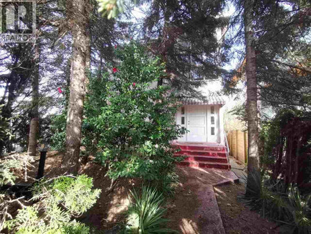
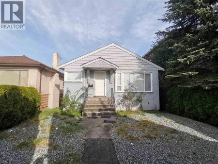
$2.998.000
2032 E 22nd Avenue, Vancouver
8 beds 7 baths 3577 sqft • Residential Home
Added by RE/MAX Select Properties 16 hours ago
Whether you're interested in viewing Vancouver real estate or homes for sale in any of your favorite neighborhoods: Central Vancouver, Fairview, Killarney you'll find what you're looking for. Currently on Vancouver real estate marked listed 780 single family homes for sale with price range from 1,356$ to 49,800,000$ with average price 4,312,723$ for 5 bedroom houses.
Hey there! If you're peeking into education options in Vancouver, BC, you're in for a treat. This city's got a smorgasbord of schools that cater to every kind of learner. You’ve got the University of British Columbia (UBC) that’s sitting pretty at the top with a global ranking that’ll knock your socks off. Then there’s Simon Fraser University (SFU), giving UBC a run for its money – talk about friendly neighborhood competition, right? For the creatives, Emily Carr University of Art + Design is where it’s at. It's like the Hogwarts for the artistically gifted. And for those juggling studies and work, the British Columbia Institute of Technology (BCIT) is the go-to. Plus, there’s a whole lineup of stellar high schools with all the A's you could wish for. Point is, in Vancouver, your educational opportunities are as vast as the ocean surrounding this coastal city.
Alright, let’s dive into the human sea of Vancouver and see who’s swimming around. This place is a mosaic of cultures, I'm telling you. It’s like the whole world decided to throw a party and everyone showed up. You've got a big chunk of the population waving the Asian heritage flag, and another big slice from Europe. It’s not just about where people come from though, it’s also about the stories they bring. You’ve got languages flying around left, right, and center. Not to mention, age groups? We’ve got the full spectrum from little kiddos to wise old owls. Let’s lay it all out on the table, shall we?
| Demographic Factor | Statistic |
|---|---|
| Total Population | Over 630,000 |
| Median Age | Approximately 39 years |
| Top Ethnicities | Asian, European, Indigenous |
| Common Languages | English, Mandarin, Punjabi |
| Education Level (Bachelor's Degree or Higher) | Around 40% |
Ever heard of island hopping? Well, in Vancouver, it’s more like city hopping. You’ve got a bunch of cool neighbors just a stone’s throw away. Richmond’s where you want to be for some of the best Asian cuisine this side of the Pacific. Burnaby’s busting at the seams with shopping and parks. And if you want to feel like you’re in a Hallmark movie, take a quick jaunt over to the charming streets of New Westminster. Oh, and if tech is your thing, Surrey’s booming with innovation. It’s like everyone around here’s got something unique going on.

Let's talk neighborhoods because Vancouver's got a flavor for every taste. You like the hipster vibe? Main Street’s where your beard and artisan coffee will feel right at home. For those of you with a taste for the finer things, there’s no place like West Vancouver with views that’ll make your Instagram pop. Kitsilano? That’s beach life and yoga pants central. And if you're into the hustle and bustle, Downtown’s got your name on it. But don't just take my word for it, have a gander at the stats and see where you might wanna drop your anchor.
| Neighbourhood | Vibe Check |
|---|---|
| Main Street | Hipster Heaven |
| West Vancouver | Luxury with a View |
| Kitsilano | Beachy & Relaxed |
| Downtown | Urban Hustle |
You know what’s more up and down than the Grouse Grind? The Vancouver real estate market. But, seriously, if you're looking to get the lowdown on housing trends, buckle up. Prices in this city have been known to soar faster than the seaplanes taking off from Coal Harbour. But every so often, they cool down just enough to let a few lucky folks jump on the property ladder. Here's a snapshot of what's been happening, but hey, this market waits for no one. So, if you see a trend you like, better move faster than a downtown cyclist.
| Statistic | Value |
|---|---|
| Average Home Price | Just north of $1M |
| Monthly Rent (2-bedroom) | Not for the faint of heart |
| Housing Price Trend | Up, up, and away |
| Inventory | As scarce as a sunny day in November |

So, you’re pondering whether to buy some digs or rent a pad in Vancouver? Well, it's like choosing between skiing or snowboarding at Whistler—it all comes down to your style. Buying’s got its perks if you’ve got the dough and you're ready for a long-term thing. It’s like planting your flag on a piece of this mountain-fringed paradise. But renting? That’s for the free spirits who want to keep their options open, maybe even have enough cash left for a poutine splurge. Either way, you’re playing the game in one of the hottest markets out there, so you better be ready to make some swift moves!
Ready to get the inside scoop on Vancouver? First things first, the food here is off-the-charts amazing – we’re talking sushi that’ll ruin you for anywhere else. And the great outdoors? They’re not just great, they’re epic. From the seawall to the mountains, nature’s always just a hop, skip, and a jump away. Culture? It’s like a buffet that never ends. But it's not just about what you do, it's about that Vancouver vibe – a mix of laid-back, eco-conscious, and downright friendly. Plus, there's always something going on, from dragon boat races to night markets that light up like a scene from Blade Runner. Just come as you are and dive in!
Alright, newbie home buyers in Vancouver, listen up. This city’s market can be as tricky as trying to find a parking spot at Granville Island on a sunny Saturday. But here’s the scoop: you’ve gotta get your ducks in a row with a mortgage pre-approval first. Then, do your homework. We’re talking neighborhoods, property types, the whole shebang. A good realtor can be your best friend through this jungle. And remember, in this market, hesitation is not your friend. If you find a place that checks all your boxes and doesn’t have you eating instant noodles for the foreseeable future, make that offer. Welcome to the wild ride of Vancouver real estate – it’s about as adventurous as mountain biking down Mount Seymour!
In addition to 1583 Condos in Vancouver, we also found 807 Houses, 274 Commercial listings, 250 Townhomes, 226 Duplex listings, 33 Vacant land listings, 1 undefined, 1 undefined. Research Vancouver real estate market trends and find homes for sale. Search for new homes, open houses, recently sold homes and reduced price real estate in Vancouver. Each sale listing includes detailed descriptions, photos, amenities and neighborhood information for Vancouver.
| Nearby Cities | Listings | Avg. price |
|---|---|---|
| North Vancouver Real Estate | 553 | $1.765.231 |
| West Vancouver Real Estate | 375 | $4.374.519 |
| Richmond Real Estate | 947 | $1.578.772 |
| New Westminster Real Estate | 309 | $1.406.564 |
| Port Moody Real Estate | 117 | $1.483.193 |
| Delta Real Estate | 320 | $1.664.490 |
| Coquitlam Real Estate | 678 | $1.732.474 |
| Bowen Island Real Estate | 76 | $1.978.393 |
| Popular Cities | Listings | Avg. price |
|---|---|---|
| Burnaby Real Estate | 1002 | $1.333.402 |
| Surrey Real Estate | 3242 | $1.607.167 |
| Langley Real Estate | 1188 | $1.892.135 |
| Maple Ridge Real Estate | 753 | $1.439.072 |
| Abbotsford Real Estate | 799 | $1.355.530 |
| Nanaimo Real Estate | 881 | $936.747 |
| Chilliwack Real Estate | 713 | $1.022.774 |
| Penticton Real Estate | 647 | $820.931 |